Indus in Peril: How Human Interference Turned Sindh’s Lifeline into a Flood Zone
 Ishak Soomro
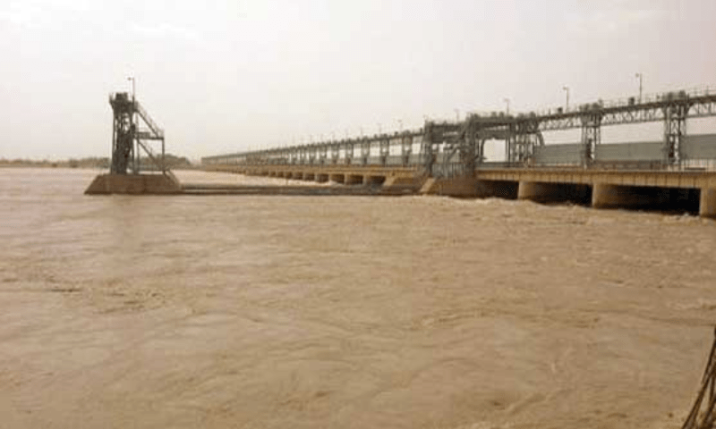
The waters of various rivers travel thousands of miles before reaching their final destination—the Arabian Sea—via the mighty Indus River. The river flows through hundreds of miles of floodplain in Sindh, serving as the natural and ultimate basin for the powerful currents of five rivers. This is why Sindh must always be prepared for both minor and major floods.
At the point called "Panjnad" in Punjab, the waters of five rivers—Sutlej, Ravi, Chenab, Jhelum, and the Indus itself—converge and enter Sindh through Kot Mithan and Guddu Barrage. Until this water reaches the sea, the people of Sindh remain in a state of danger.
Due to an unusual increase in water levels in Punjab’s rivers, headworks and barrages are under immense pressure and at risk of collapse. The Punjab government has deliberately breached several embankments—essentially “bombing” them—to reduce water levels and save key cities and barrages from flooding. However, this led to the submergence of less significant towns and areas, forcing millions to temporarily relocate. This reduction in water pressure has significantly decreased the flood intensity, benefiting Sindh.
The Indus River, one of the world’s largest river systems, is surrounded by approximately 7,000 kilometers of flood-control embankments and about 1,400 spurs. In Sindh, the river irrigates the entire province from Kashmore to Keti Bandar. When the British conquered Sindh in 1842, they established forestry and irrigation departments to make the land fertile and boost grain production. In 1860, protective embankments were built on both sides of the river to control its flow for agricultural use.
Later, in 1932, the Sukkur Barrage was completed, allowing the river’s water to be used for agriculture in Sindh. This led to significant development in the agricultural sector, and the area between the riverbanks came to be known as "Kachha."
Irrigation experts categorize floodwaters in the Indus River into three levels:
- A flow of 50,000 to 100,000 cusecs is considered a normal flood, which keeps the floodplain safe.
- A flow between 100,000 to 200,000 cusecs submerges about 10% of the area.
- Between 200,000 to 300,000 cusecs, 20% is affected.
- At 400,000 cusecs, 35–40% of the area is submerged, damaging crops and homes.
- A flow above 500,000 cusecs floods 60–70% of the region.
- At 700,000 cusecs or more, up to 90% of the floodplain is underwater.
Sindh’s floodplain, stretching from Kashmore to the delta, covers 2,011,200 acres. Of this:
- 1 million acres are used for agriculture,
- 600,000 acres lie within the river’s central channel,
- 450,000 acres are under the forestry department,
- and the remaining 50,000 acres consist of lakes, villages, and non-agricultural land.
Fifty years ago, 750,000 people lived in the floodplain. Today, the population exceeds 3.5 million—more than the populations of countries like Kuwait, Qatar, Bahrain, Bosnia and Herzegovina, Jamaica, Armenia, Lithuania, Mauritania, Monaco, Gibraltar, Albania, Luxembourg, Maldives, Brunei, Bhutan, Grenada, Barbados, and around 70 other nations.
According to official data, over 1.78 million acres of the floodplain are occupied by influential landlords. These lands host lakes, private homes, tube wells, and even illegal embankments, where farming is carried out in their “Katians.” Forty-five years ago, 42% of the floodplain was forested. Now, due to agricultural expansion, forest cover has dropped to less than 5%, severely disrupting the river’s natural system.
In 2004, Sindh’s forestry department introduced the "Agro-Forest Lease Policy" to expand riverine forests. Thousands of acres of barren land were leased, benefiting thousands of people. However, agricultural development, deforestation, and illegal embankment construction have obstructed the smooth flow of the Indus River.
Additionally, new bridges over the Indus—especially the one connecting Larkana and Khairpur (1.22 km long, while the river’s width between banks is 13 km), and the Qazi Ahmed–Amri bridge (1.32 km long, with a river width of 9 km)—have created flow obstructions due to their pillars and narrowing of the riverbanks. In 2010, it took 400 hours for water to travel from Sukkur to Kotri Barrage. Before these bridges, the same journey took only 72 hours.
Nature lovers argue that floods are not our enemies; rather, it is human interference with nature that has turned a blessing into a curse. For thousands of years, humans and river waters coexisted peacefully. But once humans began tampering with nature, they started suffering the consequences. Floods are not a sin—the destruction they cause is due to poor management. Pakistan must improve its flood management. If the Sindh government ensures the protection of embankments and allows the sweet waters of the mighty Indus to reach the sea, major financial and human losses can be avoided.